CITY ANIMALS

In collaboration with the Arroyos and Foothills Conservancy (AFC), a local nonprofit dedicated to conserving and protecting natural open spaces to combat climate change and support wildlife habitats, this Designmatters Transdisciplinary studio engaged students in exploring the challenges of habitat fragmentation through the medium of data visualization. The students learned about local urban wildlife conservation efforts aimed at preserving biodiversity and fostering coexistence between residents and their wildlife neighbors. AFC granted students access to many subject matter experts along with many sources of data, including dynamic mapping tools and 85 wildlife cameras. Teams visualized how data can be best conveyed to LA County residents, policy makers, researchers and conservationists; they conceptualized and developed engaging visual solutions, experiences, and artifacts that communicate the reality of wildlife living among us, conservation issues that may need to be addressed, and basic urban wildlife information.
“Each team focused on something that I can see the application. I see usability for each one. They’re all great; they all spoke to me in different ways. These are a different way to tell a story, it’s a different language. These projects represent different ways to express ourselves.”
John Howell, Chief Executive AFC
About Arroyos and Foothills Conservancy
The Arroyo & Foothills Conservancy preserves land and restores habitat in and around the San Gabriel and Crescenta Valleys, thereby protecting natural areas for birds and wildlife and providing access and educational experiences for the community.
The need for biodiversity in urban areas is real. Communities of natural flora and fauna suffer without sufficient access to open space. Wildlife are stranded in isolated islands of habitat, resulting in decreased opportunities for breeding and accessing food and water, eventually leading to local extinction. Wildlife corridors provide passageways suitable for the movement and dispersal of wildlife, including mammals, birds, butterflies and native plants. AFC is working to connect these islands with corridors that invite wildlife to pass freely from one area to another, and allow these urban habitats to adapt to climate change.
“Taking Designmatters classes gives you a very different point of view to see design and see your role in the society, instead of this bubble of art. We are very professional and in these very niche fields we’re often surrounded and closed off from others. Sometimes I think like we don’t understand how our skillsets would affect the world, economically or politically. And I do think that designs matter.”
Xiao Ye (Guisti) Yang, student
Research and Project Development
At the kick-off session, representatives from the Arroyos and Foothill Conservancy (AFC) joined the studio to present an overview of their organization. Students learned about the origins of the nonprofit, how active citizens began saving undeveloped land to be set aside for wildlife to enjoy – and to unite fragmented wild areas for a connective habitat of plants and animals. AFC reps described how LA County residents often share space with urban wildlife such as coyotes, big cats, bears, bees, birds and more. To maintain a healthy biodiversity and protect wildlife species for future generations, humans must understand their impact on the landscape and learn to live side-by-side with their wild neighbors.
AFC is connecting land fragments through acquisition to create a corridor for wildlife to live in and around. This connectivity is vital to the health and well-being of animals and plants. To date, AFC has conserved approximately 90 acres of land, working with six communities to strategically acquire acres. With a mission of conservation, research and education, AFC sees itself as a science-based organization. To learn which animals occupy the land parcels, AFC installed 85 cameras to capture footage as part of ongoing data collection.
After the presentation, students asked question to better understand the needs of AFC as well as the various complex data that has been collected through the years. Later, as students debriefed the information, they examined the basic elements of data visualization and how it may be used in this particular project. Teams were encouraged to view data visualization as a way to reveal hidden and complicated relationships into visuals that are easy to understand at a glance.
Through the first weeks of the studio, students dived deep into the various data visualization techniques and explored different ways to look at data. Through in-class exercises and assignments, they took data and patterns to build physical representations, immersive experiences and visuals; stepping back they examine their results from different angles to see how their message could be received or misconstrued. Teams employed various coding programs that are accessible to artists and designers in addition to learning ChatGPT strategies that can assist with development, ideation validation and audience role-playing.
Field Trip Insights
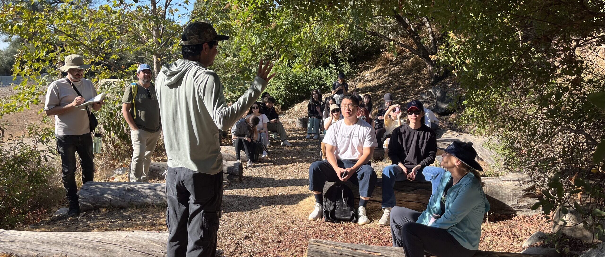
Students had the opportunity to tour two AFC preserves for a first-hand experience in the land parcels and their proximity to urban residential areas. Teams heard from AFC staff at their outdoor classroom where students of all ages learn about plants, geology, indigenous people and the reciprocal care relationship of humans to nature. AFC explained how many residents (students, families, etc.) come to the preserves because “they want to have an experience in nature.” AFC reps told the students as they began exploring the habitat: “Reframe the way you think about environments. Experience the land through your senses.”
From one high vantage point, students noticed various obstacles that wildlife encounters (streets, parking lots and other man-made structures) that hamper their ability to roam safe and freely. As they hiked the trails, student teams were imagining how they could reframe these physical experiences (smelling native plants, observing deer across a small ravine, etc.) into a compelling digital/visual/tactile experiences. Students noticed AFC trail cameras that record wildlife observations. Back in their classroom, students continued to examine the AFC data, mapping software and digital interaction techniques as they worked toward midterm presentations.
At midterm, teams pitched AFC their preliminary concepts; the teams presented how they viewed the challenge, insights from their research, potential target audiences and inspirations.
“The most important thing I saw was that students were able to work with an outside partner to understand the dilemmas that we see. They really embraced working with Arroyo and Foothills Conservancy and understanding our challenges. Everybody was impressed with that. The other thing is that the teams were very clear about their audience. They all had different audiences and solutions. They also had every different level of emotional connection. Across the board, I thought the students grasped the breadth of the challenges.”
Katie Poole, AFC board member
They offered possible directions that ran the gamut: simulator, app, large projection, board game, interactive poster, musical sculpture, AR applications, holographic installation and others.
AFC reps were enthusiastic about the directions from the students, offering suggestions and modifications that could streamline their ideation. AFC was excited about how the different technologies could tell and showcase their story and the bigger story of living with urban wildlife. Teams asked questions wanting specific advice, clarifications and suggestions to keep their projects on track.
As teams continued refining their projects, they were guided by class room lectures and hands-on lessons in prototyping. The class welcomed a guest lecture from Data Vandals, a grassroots duo that combines guerilla urban art and data visualization into clever, colorful and exciting installations. Group meetings with Data Vandals and the faculty helped teams propel their projects forward. They honed their presentation skills to be clear speakers with a strong emphasis on the elements of good storytelling.
Each team created a short video from one person’s point of view on how they discover the solution, showing the steps of engagement and how information is communicated. These videos were played during final presentation where they established the team’s context and tone along with showcasing how their project can be used and experienced by a target audience.
Outcomes
 close
close
My Wild World
Read moreTeam Coyote: Arlene T. Antonio, Alexandria (Lobster) Aragosta, Joonhee Park, Tim Shih
This app helps local residents recognize their role in the ecosystem and to specifically help gardeners choose the right plant for the right location. The My Wild World app invites users to input their physical location, scan their backyard and note water and sunlight sources. Users select what type of wildlife they would like to attract. These data points help determine the best plants to thrive in this location. Users can share their wildlife observations – butterflies, birds, etc. – in a crowd sourced data base. These photos can be easily taken with smart phone and tagged with a GPS location.
 close
close
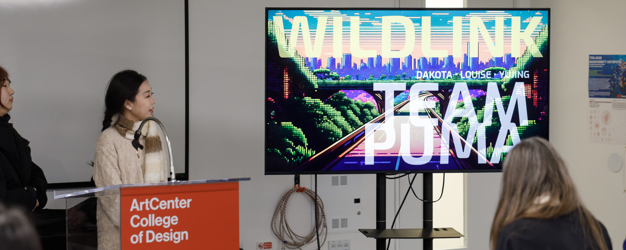
Wild Link
Read moreTeam Puma: Xiaoye (Louise) Liu, Wenqiu (Dakota) Shao, Yujing Wang
As junior and high school students play a game on a large interactive white board (with a goal to protect the mountain lion) they gain a better understanding of the importance of wildlife corridors and safe passageways. The screen on the interactive white board is set up like a board game. Students choose a large puzzle piece from a variety of pieces that are grouped into four categories: Facts, Problems, Data and Action. Once placed on the screen, the piece triggers animation and audio as they are snapped into place. When a piece is in a good position, the user hears a positive trill – and the white board gives a short fact; the user can then select the next piece in the journey. A bad choice results in a red screen color and a negative noise. Creating a successful connection causes an animated mountain lion to move through the puzzle pieces with ease.
 close
close
EcoConstruct
Read moreTeam Bobcat: Jiazhuo (Jerry) Cai, Luoyi Guan, Yilin Jin
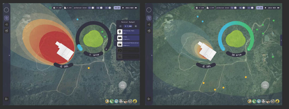
This interactive digital map allows users to see the direct effects of introducing certain man-made elements into a natural environment. Players first chose a geographical area that’s displayed along with topographical facts and natural history elements. Users select which wildlife that would to study; data points of that animal’s location appear on the map screen. By placing a physical control knob on the map screen, users can turn the knob to reveal different animals in the area. To simulate how these animals react to human activity, players select other physical pieces such as housing development, greenery, industrial structures, etc. Once placed on the map, the piece is turned to simulate how that element affects the wildlife points. Turning the data knob, visuals appear that showing the impact on these animals and the environment. The map also accesses air quality data and can depict the impact of introduced elements (such as factories) and how that pollution can be mitigated by planting trees. Urban planners can use this tool for restoration strategies and planning insights.
 close
close
Symbiosis
Read moreTeam Deer: Jiaqi (Vanessa) Huang, Nick M. Rheem, Yupeng (Hank) Zhai
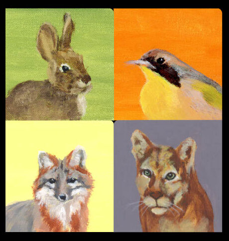
Black and white imagery is projected on a large open wall. The screen reveals facts about the diversity of urban wildlife in Los Angeles – and the importance of biodiversity. An animated light show features a map of the Southern California coastline with white circles on a black background that corresponds to animal data points. As human activity is introduced, red points appear and the animal points retreat. Three animals (mule deer, red fox, monarch butterfly) are highlighted; first with a dramatic fact; afterward data points swirl together and create imagery of that animal moving with others. The white dots almost appear as stars against a black sky. Dramatic music swells appropriately. Final call to action is the need to conserve land for our wildlife and for ourselves: “A city without animals in a city without balance.”
 close
close
Parcel Explorer
Read moreTeam Chipmunk: Carolyn Hsu, Wen-Hsun (Claire) Li, Xiao Ye (Guisti) Yang
Local residents who use this interactive simulator on the AFC website become more informed about the relationship of humans and wildlife. A geographical area is illustrated with significant features in a highly abstract format that reflects a real topography of parcels, mountains homes and roads. Players click to discover which animals have been seen in the areas (deer, coyote, etc.), the time of day, year, etc. Then players try to choose the safest route for animals to go from one green parcel to another, avoiding challenges such as freeways, light pollution, industrial buildings, and invasive plants. Users can also click on actions that can open up pathways for the animals.
 close
close
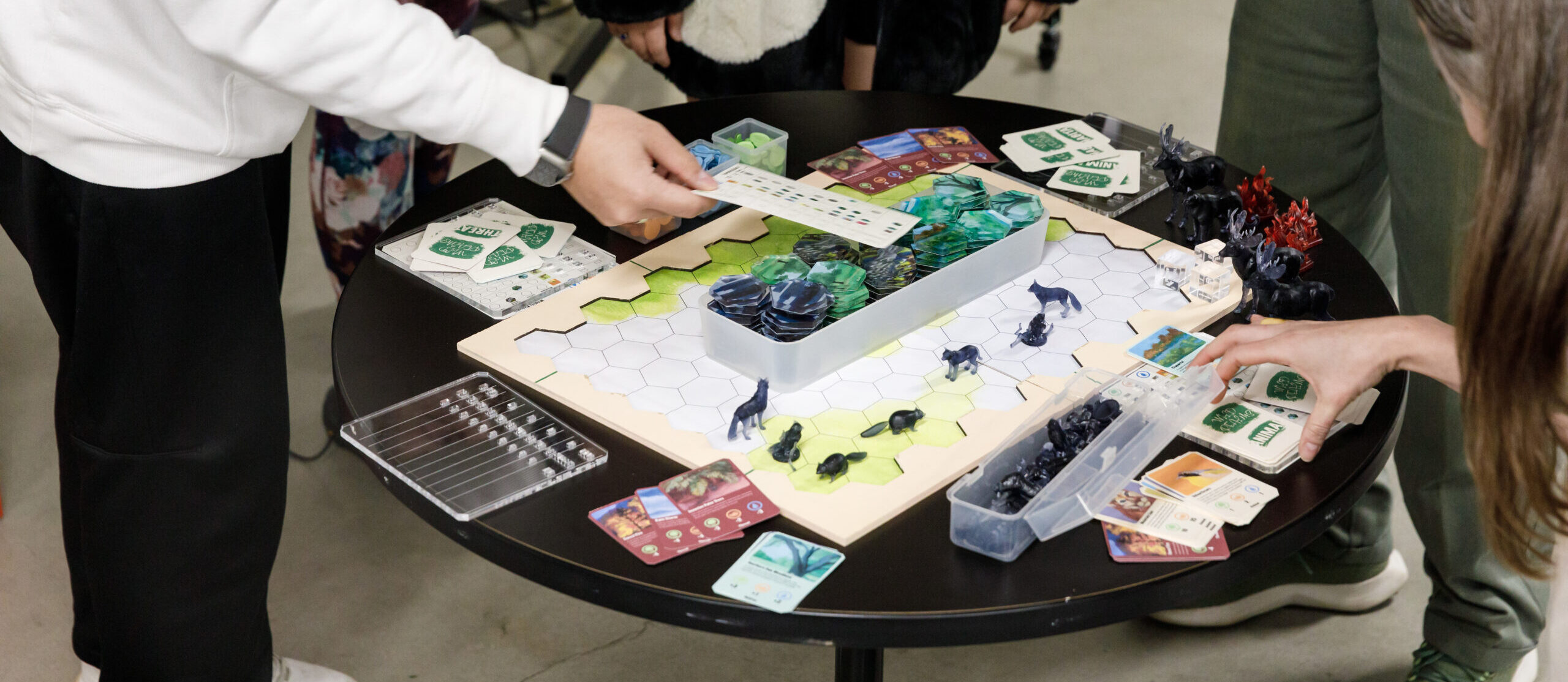
Wild Realm
Read moreTeam Crow: Kejia Chen, Yida (Jason) Jiang, Morgan Wiemer
This four-player card and board game invites players to learn first-hand how interconnected elements are in nature and how humans can be a part of that process. Players first choose a role: urban planner, environmental educator, activist or wildlife biologist as they navigate the board and contribute to the bigger picture of helping wildlife. Players learn how to strategically expand Southern California natural habitats (oak woodlands, stream riparian, sage scrub and chaparral) by laying down hexagonal tiles on the board. Before they can place a tile, however, they roll a dice and must deal with obstacles such as environmental threats. As land is gained, players receive resource tokens which allow them to place a 3-D animal figurine onto the saved land. Each species is worth different points and the game progresses upward on the food chain to the top predator of all, the mountain lion. A winner is one who has collected the most resource tokens (animals) and land.